
This is what we've been living in for the last 8 months!

The bedroom and living room "slides" to allow for more space
when stopped. Makes a huge difference.

The western squirrels have cute long ears

The ravens out here are huge!
We explored Flagstaff, a college town that reminded me a bit of Yellow Springs, Ohio. Quirky, artsy, and outdoorsy - there were lots of cute art shops, outdoor outfitters, hiking, skiing, rock climbing, etc.

Cute local art co-op

Church in Flagstaff

Historic hotel in Flagstaff

"Yarn Bombed" bike stands in Flagstaff art district
Just outside the city is Sunset Crater National Park - this volcano blew up about 900 years ago and the area is still covered in cinder. It was like being on the moon it looked so different. We mostly drove through the first section of the park and walked a short trail, but it was enough to get a good feel of the area.

walking the lava rock path


That is the actual cinder cone of the volcano

Black, rough lava rock, even after 900 years, has little soil

A nice view of the San Francisco mountains; still
with snow on its peaks
We left Flagstaff and continued north, stopping at the Cameron Trading Post on part of the Navajo Nation Reservation.

How sweet is this little face?

Beautiful handmade Kachina

Sand paintings in recycled glasses and baby food jars!

Tapestry and Kachinas over the fireplace in the restaurant
part of the trading post

Navojo weaving....incredible, and incredibly expensive!
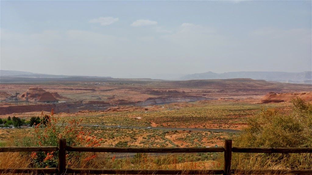
We ended up in Page, Arizona. Again, only a few hour drive, and yet again, the terrain and landscape is completely different! Page is a town that was founded in the 1950s during the building of the Glen Canyon Dam.
Glen Canyon Dam is a concrete arch dam on the Colorado River in northern Arizona in the United States, near the town of Page. The dam was built to provide hydroelectricity and flow regulation from the upper Colorado River Basin to the lower. Its reservoir is called Lake Powell, and is the second largest artificial lake in the country, extending upriver well into Utah. The dam is named for Glen Canyon, a colorful series of gorges, most of which now lies under the reservoir. (taken from Wikipedia)
The landscape is basically rocks as far as the eye can see in all directions. And its almost always windy here. We're talking WINDY as in hold on to your hat and your skin, because the sand is picked up in the wind and its like a full body dermabrasion treatment. And that same sand that is pelting your face is pelting the rocks, creating weird, windswept patterns in the soft sandstone (basically petrified sand dunes).

More strange rock formations, jutting out of the earth
Rocks as far as you can see

Rocky landscape

Windswept sandstone
We drove a few miles along Lake Powell:


Our first full day in Page we just got our bearings, explored the town, stopped at some scenic overviews and went to Horseshoe Bend. Horseshoe Bend is an iconic picture seen in about every publication about the west and the Colorado River. According to the article we had clipped out of the paper for directions, it was 5 miles out of Page and while you couldn't see it from the road, it was just a short walk to this beautiful scenic overlook. Short walk my A@@! The sign said it was .7 (that's POINT 7 - not even a mile). Does this look like less than a mile to you?

Those are people way out there.
So we walked down to the overlook - which was so much more beautiful than any pictures could show. There were about 75 people on the trail coming and going, 99% of them foreign tourists, and we got a kick out of how many asian tourists climbed out of one van! LOL

People kept getting so close to the edge!

Horseshoe bend - I didn't get close enough to the edge
to get the full picture. Sandstone is soft and you never know what
has eroded underneath you, which is how people are killed
here on a regular basis. No rails, so you are supposed to use
common sense - obviously not so common anymore
Funny story: As we were walking at one of the overlooks, I was taking pictures of some of the flowers growing out of the rocks. One plant in particular had a wonderful smell, so I plucked a leaf and crushed it between my fingers to get a good whiff. I poked it under Noel's nose so he could smell it. There were two couples walking towards us, and one of the women was looking directly at me and I thought was listening, so I walked up to her and said "Doesn't it smell wonderful?" and poked that leaf right under her nose. Well, they didn't speak English and were quite taken aback by this large stranger trying to stick something under their nose! LOL Wouldn't you know, at the next stop at Horseshoe Bend I was taking pictures when I saw a little lizard in the bushes. I saw out of the corner of my eye some people walking with a camera, so I stopped them and pointed to the lizard so they could see it too. Wouldn't you know, it was those same people, who again looked at me like "Why is this crazy American women bothering us again?" I finally gestured enough for them to understand I was just trying to show them the lizard, but I was pretty embarrassed, so no more talking to tourists for me!!

Here, SMELL THIS!

I wonder how you say lizard in French?
What the article about Horseshoe Bend failed to mention is the 3/4 mile back to the parking lot is pretty much ALL uphill, and mostly in deep, soft sand. About 1/2 way up I would have gladly paid a LOT more in taxes for an escalator and oxygen station. Its one thing for me to hike uphill on a paved or rocky path, but that sand about killed me. It was only about noon, but I was done for the day. I went home and took a 3 hour nap.

Even the next day I couldn't leave the trailer I was so exhausted and in pain. But there is too much to see here to miss it, so the next day we drove out to Monument Valley Navajo National Park. Its about 150 miles from Page, and most of the park is a 17 mile unpaved dirt road through the valley, so it didn't require too much hiking, just hopping out of the truck to take some pics, than back in my extra cushioned seat (Noel takes such good care of me). Monument Valley is on the Navajo Nation, and we made one stop along the way at the Navajo National Monument, an Anasazi Indian Ruin.


The ruins are at the base, inside the alcove

Mind you, this thing is huge - hard to capture in pictures

breathtaking views

As we drove through the Navajo reservation, we saw lots of wild horses (they call them feral horses), and it looked like the set of a western move! And again, the terrain was changing...


I can't help but wonder how/why these giant rock buttes jut out of the earth in the middle of an otherwise flat field....

Beautiful patches of purple flowers

every once in a while, you would see the Navajo artists set up
alongside the road selling jewelry, dream catchers and other trinkets

A giant rock just all by itself in the middle of nowhere

Another one - strange


the only mammal we saw in the park


See the little white speck at the base of the rocks? That's a pick up truck!
That gives you an idea of the size of these things


The Three Sisters formation - dibs on being the skinny
one in the middle!

The little white specks at the base in the middle of the picture?
Those are people on horseback.
Driving home, we noticed a sign - is that what I think it is?

Yep - A yard sale - in the middle of no where! I wonder how many miles long their
driveway is? I wonder if they ever got any customers?
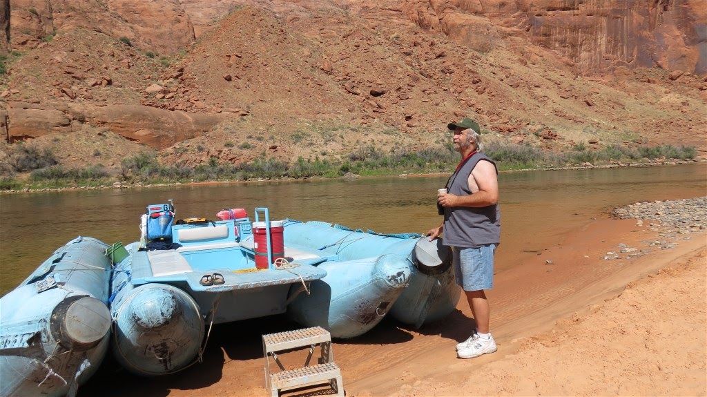
So today, Saturday, we had reservations with a Colorado River Outfitter to smooth water raft down the Colorado River. It started out with a bus ride, down through a TWO mile tunnel through the rocks, to the base of the Glen Canyon Dam. We had to pass through homeland security, and wear hard hats as we walked along the base of the canyon walls to the pier.


I think I've seen too many scary movies - I kept expecting to
see some creepy little girl in a white dress holding
a doll just appear in front of the headlights in this
pitch black, did I mention it is two miles, tunnel

The road bridge over the river

The Glen Canyon Dam
Our group consisted of Noel and I, a young couple from the Netherlands, two young men from Italy, a surfer dude and his girlfriend from San Diego, California, and a young couple from Rhode Island. We floated along, slowly meandering down the river. It was beautiful.


Fly fisherman


The arrow? That's a full size boat with three men. The walls of the
canyon are around 1100 feet high!
About two hours into the trip we pulled over onto a sandy beach area and were afforded a bathroom break, hiked down a path to see some indian petroglyphs and could have waded/swam if we wanted. The water temperature is 49 degrees. We passed on the wading part.

chuck walla lizards

There's a face only a mother could love!

Ancient drawings on the rocks

More petroglyphs
So as we floated down the river, we came to Horseshoe Bend - the same place we saw from above a few days ago. With my telephoto lens and with Noel's binoculars, we could see the teeny, tiny figures of people at the top.

picture of Horseshoe Bend from the brochure

Those are people up there! Good luck hiking back
you unsuspecting tourists, you!

And that's how people get killed - falling 1100 feet when a
rock breaks off - just to be "kind of the world" for 10 seconds.
I can't even look!

rocks are frequently breaking off and falling, as you
can see, because sandstone is very soft! That's a great blue
heron on the big rock by the water.
Speaking of great blue herons, there are rookeries (nesting areas) of herons along the cliffs, nesting in trees and maidenhair fern clusters. That was one of my favorite parts of the trip!

The trip down river was at a slow pace, the way back, our guide cranked it up and we began our way back to the dock.
First, we hit a shallow area and the propeller broke. She was able to quickly change it out with a spare. Then, the engine died abruptly. She switched to a back up gas tank, but upon starting it up it began to smoke. She quickly shut it off, and we began to drift. She couldn't reach anyone on the walkie talkie and had no signal on her cell phone. We continued to drift, having to shout to the fly fisherman our apologies as we drifted into their space so they could reel in their line. She finally had one bar on her cell phone so she texted for help. We drifted about 20 minutes when it was clear we were headed for a large rock in a small rapid, (one that we had avoided on the way down). There was only one oar, so she started frantically trying to steer us. One of the young men grabbed the broom and between the two of them we avoided the rock. We finally drifted close enough to the shore that the guide was able to jump out on the rocks and pull us to the shore while we waited for the rescue boat to arrive.
Another raft/boat arrived and we all transferred over to it for a ride safely back to the dock, back through the tunnel and back to the trailer safe and sound with a great story to tell and beautiful images burned into our memory banks! And in spite of the hiccup, I would highly recommend this trip. It was awesome, though I kind of hoped to at least get a free tee shirt for the unscheduled drama! (no such luck)

changing the propeller

rowing with one oar and a broom to get us to shore

Help has arrived!
A few more various shots

A beaver dam under the water

A fancy shot

Called "Coyote Rock" - see the howling coyote?

Pretty - wish their heads weren't in the picture!
So I hope everyone has a wonderful Mothers' Day!
2 comments:
Happy Mothers Day to you! I am enjoying your blog - it is so interesting and educational! Thank you for sharing!
This blog post is AMAZING!! All of them are Anna but the photos and all you experienced are phenomenal!!!You are SOOOO brave to go in that 2 mile tunnel but definitely worth it!
Just beautiful, loved it as always.
Post a Comment